Bharat Mata Mandir
| Bharat Mata Mandir | |
|---|---|
भारत माता मंदिर | |
 | |
| Religion | |
| Affiliation | Indian Nationalism |
| District | Varanasi |
| Deity | Bharat Mata |
| Festivals | Independence Day Republic Day |
| Location | |
| Location | Mahatma Gandhi Kashi Vidyapith, Varanasi |
| State | Uttar Pradesh |
| Country | |
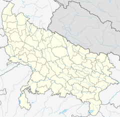
Temple location on Varanasi district map | |
| Geographic coordinates | 25°19′02″N 82°59′21″E / 25.317209°N 82.989291°E |
| Architecture | |
| Creator | Babu Shiv Prasad Gupta |
| Completed | 1936 |
| Elevation | 83.67 m (275 ft) |
| Part of a series on |
| Hinduism |
|---|
 |
Bharat Mata Mandir (meaning "Mother India Temple") is located on the Mahatma Gandhi Kashi Vidyapith campus in Varanasi, Uttar Pradesh, India. Instead of traditional statues of gods and goddesses, this temple has a huge map of Akhand Bharat carved in marble. This temple is dedicated to Bharat Mata and was originally the only one of its kind in the world,[1][2][3][4] though a few others have now been built. The Bharat Mata Mandir was created by philanthropist and freedom fighter Shiv Prasad Gupta.[5]
The temple was inaugurated by Mahatma Gandhi in 1936. Gandhi said: "In this temple there are no statues of gods and goddesses. Here there is only a map of India raised on marble. I hope that this temple will take the form of a worldwide platform for all religions, along with Harijans, and of all castes and beliefs, and it would contribute to feelings of religious unity, peace and love in this country." Khan Abdul Ghaffar Khan and Vallabhbhai Patel were also present during the inauguration.[6]
Construction
[edit]The Bharat Mata Mandir structure is built of stone. It has a statue of Bharat Mata built of marble, symbolizing Akhand Bharat.[7] The temple houses a relief map of India also carved out of marble. The map depicts the mountains, plains and oceans up to scale. It has no "murti" or image of God so that the temple is inclusive to all religions in the country and secular.[5]
-
The relief map of India
-
The relief map of India
-
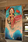
Bharat Mata picture in the temple
Varanasi and Ujjain
[edit]Bharat Mata Mandir is situated on the campus of Mahatma Gandhi Kashi Vidyapith and is 1.5 kilometers south of Varanasi Junction railway station and six kilometers north of Benaras Hindu University.[8]
There is a Bharat Mata Temple situated near Mahakaleshwar Jyotrilinga temple at Ujjain. It is a big temple with a statue of India .
See also
[edit]External links
[edit]https://www.varanasiguru.com/bharat-mata-mandir/
References
[edit]- ^ "Bharat Mata Mandir". varanasi.org. Retrieved 3 March 2015.
- ^ "Bharat Mata". varanasicity.com. Retrieved 3 March 2015.
- ^ "LP". Lonely Planet. Retrieved 3 March 2015.
- ^ "Temple news". The Times of India. Retrieved 3 March 2015.
- ^ a b Ramaswamy, Sumathi (2010). The Goddess and the Nation: Mapping Mother India. Duke University Press. p. 160.
- ^ Charu Gupta (2005). Sexuality, Obscenity, Community: Women, Muslims, and the Hindu Public in Colonial India. Orient Blackswan. p. 200.
- ^ Karkar, S.C. (2009). The Top Ten Temple Towns of India. Kolkota: Mark Age Publication. p. 11. ISBN 978-81-87952-12-1.
- ^ "Location". Google Maps. Retrieved 3 March 2015.


